
Winnebago Neighbor Sources by Block
No official source supplies a complete roster of neighbors. A careful block lookup combines parcel geometry, selected ownership records, recorded land instruments, and the city’s community layer. Each source answers a narrow question, and none proves every person present at an address.
| Source | What It Shows About a Block | Access |
|---|---|---|
| WinGIS parcels and PINs | Adjacent geometry, parcel identifiers, and map details | Public map using click, pan, and Details |
| WinGIS buffer and markup | Radius or highlighted parcel visualization | Features vary by 2026 release; not a resident list |
| Assessor and Treasurer | Owner or taxpayer for a selected parcel | Search parcel by parcel; no occupant roll |
| Recorder | Deed, plat, and legal chain for selected land | Index, office, image, and copy routes vary |
| City neighborhood map | Named association or group areas | Public map and legend; no member directory |
| Neighborhood Voice | City connector and association-help route | City program contact |
| Voter lookup | Confirmation of one specific registration match | Name and birth-date search; full file restricted |
| Sanborn and library maps | Old structures, block shapes, and number context | UIUC, LOC, RPL, and museum consultation |
A parcel owner may be one of your neighbors, but the record can also name a trust, company, public body, or remote owner. Use “adjacent owner” when that is all the source proves. Reserve “resident” for a record that actually supports residence.
Map Winnebago Neighbors in WinGIS
The WinGIS public property map provides the clearest starting point. Search the target address, open Details, and set a scale that shows parcels beside it, across the street, and behind it. The map warns that Markup and Measure change selection behavior, so close those tools before trying to select a parcel.
- Find the starting address or use its PIN in Parcel Summary.
- Open Details and record the target PIN. Do not rely on a visual boundary alone.
- Click each parcel immediately beside, behind, and across from the target. Save each PIN.
- Check each PIN in the Assessor or Treasurer system, keeping the situs and mailing address separate.
- For a selected parcel that needs ownership history, match its legal description in the Recorder index.
This flow creates a list of parcels and recorded owners, not a list of people inside homes. A single PIN can represent vacant land, a condo common area, commercial space, public land, or an entity-held property.
The 2026 WinGIS releases improved combined PIN, address, and owner search, Parcel Summary loading, buffer results, and parcel labels. Save the date because the available controls can change.
Compare Winnebago Neighbor Parcel Groups
A buffer draws a geometric area around a point. WinGIS release notes say buffer results gained a table view. The August 2026 release also added mass highlighting with address and parcel-number labels and a Comparison selection type for two PIN lists. These tools can organize a small radius or compare two saved parcel sets.
Use the buffer as a mapping aid only. Distance does not define a social neighborhood, a legal subdivision, or a household. Keep the parcel layer name and release date in notes. When a map layer shows zoning, flood, ward, ZIP, inspection, fire, police, or association areas, treat each as a separate boundary with its own purpose.
Mapping tip. Save PINs first, then verify each parcel in its source system before attaching an owner name.
Check Winnebago Neighbor Parcel Owners
The Winnebago County Assessor search accepts a four-part PIN, street number, direction, street, suffix, and owner first or last name. The Treasurer tax search uses similar fields and adds mobile-home options. Both can help confirm which tax parcel was clicked.
Record labels matter. A situs address is the property location. An owner or taxpayer mailing address is where correspondence goes. They may differ. If an exemption appears, it can be an owner-occupancy clue, but not proof of every person who lives there. Tax payment fields also say nothing about household membership.
- Parcel
- A mapped unit of land identified by a PIN.
- Situs
- The physical property address.
- Taxpayer
- The named tax account party, who may not live at the parcel.
- Plat
- A recorded map of lots, blocks, streets, or a subdivision.
For an entire named road rather than the immediate block, the Winnebago County street directory follows the address chain at street scale.
Read Winnebago Neighbor Block Deeds
Recorded deeds and plats help explain why nearby parcels have their present shape. Start with a PIN and legal description, then use the Recorder’s Direct Search by grantor or grantee. Match the legal description before accepting a same-name result. A grantor transfers an interest; a grantee receives it.
A subdivision plat can show lot and block numbers, streets, common land, and recorded geometry. It still does not identify current neighbors. The Recorder also offers public office stations, formal search and copy routes, pay-as-you-go Tapestry, and subscription Laredo. Its online historical cutoff is not stated, and staff do not accept telephone searches.
Use this step for a boundary or ownership question, not as a routine sweep of every household. When a road or parcel changed, the legal description is more reliable than a familiar neighborhood label.
Winnebago Neighbors on Rockford’s Map
The official Rockford neighborhood-association legend is unusually detailed. It mixes neighborhood associations, watches, block clubs, condo groups, historic districts, subdivisions, business areas, and civic coalitions. That variety is useful, but the layer is not a legal parcel boundary or private membership roster.
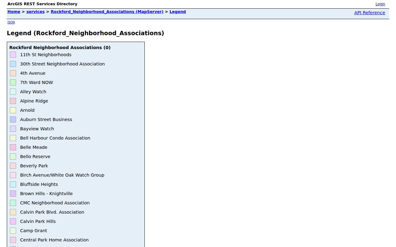
The captured legend shows why a mapped name should be preserved exactly and checked against the city contact route before being treated as an active organization.
Names include Garfield Avenue Historic District, Haight Village Historic District, Edgebrook Watch, Mulford Hills Watch, Cunningham St. Block Club/Ethnic Village, Rolling Green Association, SWIFFT and SWIFTT variants, and Twin Sisters Hill or Hills variants. Do not silently normalize those spellings or imply one umbrella organization. The map records the city layer’s labels.
Winnebago Neighbor Community Contacts
The Rockford Neighborhood Voice program supplies the human contact route. Existing associations may host meetings, events, local projects, and improvement work. Where no group exists, a Neighborhood Specialist can help residents form one. The city also describes block connectors.
Neighborhood Voice
425 E State Street
Rockford, Illinois
779-348-7300
Monday–Friday, 8 a.m.–5 p.m.
Official Map Layer
Use the association legend to find the mapped group name. Ask the city for the appropriate public contact route; the legend does not provide member names.
This is the proper way to ask whether a group serves a block, learn about a public meeting, or seek help organizing. It respects the difference between a civic contact and a household directory.
Winnebago Neighbor Voter Limits
No official county street or block voter browse was found. The Illinois voter registration lookup is person-centered and used to verify a specific match. A full voter file is a controlled product for qualifying political purposes and is subject to use restrictions. It should not be turned into an indiscriminate list of nearby names.
A block contains registered and nonregistered people. The public system does not show ballot choices. Illinois Address Confidentiality Program and protected-voter rules can also withhold or substitute address information. An absent result therefore cannot prove that someone does not live nearby.
Note: Record the lookup date because registration and district data change.
Official Winnebago Neighbor Records Compared
Official sources are narrower than commercial neighbor tools, but they reveal where each fact came from and which office can correct it. Commercial category results may combine stale addresses, relatives, phone data, and inferred associations without a clear date.
| Question | Official Record Route | Commercial Category Limitation |
|---|---|---|
| Which parcel is next door? | WinGIS parcel geometry and PIN | May group addresses without legal lot boundaries |
| Who owns it? | Assessor, Treasurer, then Recorder verification | May retain a prior owner or merge mailing and situs data |
| What group serves the area? | City association layer and Neighborhood Voice | May infer a neighborhood from postal or marketing geography |
| Who lives inside? | No complete public household roll | May present guesses as current residents |
Use an official source when the question concerns a parcel, deed, tax account, or mapped city program. If the question cannot be answered there, state the gap rather than converting an inference into a fact.
Historic Winnebago Neighbors
For an older Rockford block, use Sanborn sheets for structures and lot numbers, city directories for names and address shorthand, and newspapers for organizations or events. Rockford Public Library holds local maps, directories, newspapers, clipping files, and photographs. Midway Village offers appointment-based access to plats, images, local-resident files, and organization documents.
The three scales answer different questions. A directory can name a past resident. A Sanborn sheet can show that the building existed and how the block was numbered. A notice can supply a dated civic or family link. Rockford’s 1893 street-number change means the old and modern address should be bridged before matching anyone.
Protect Winnebago Neighbors’ Privacy
Parcel and association layers leave many things private. They do not reveal all occupants, visitors, family members, utility customers, private phone subscribers, or ballot choices. Illinois driver and vehicle address details are governed by state and federal privacy law. Protected residents may use substitute addresses.
Lawful use. Use neighbor records for civic curiosity, property research, or personal safety. Never watch, threaten, intimidate, stalk, or harass another person.
Label the result with care: parcel, owner, taxpayer, registered-voter match, or public association contact. Those terms are not interchangeable with neighbors. A responsible block record stays small, dated, sourced, and limited to the question that prompted it.